A 900-mile belt of thunderstorms loaded with torrential downpours has prompted warnings in flood-prone regions to ‘prepare to take action’.
America’s weather woes show no signs of abating as experts re-sound alarm bells for a weekend of disruption.
Atmospheric ‘frontal systems’ fuelled by battling hot and cold air masses could push the tornado total beyond 120, experts warn.
It comes as killer storms plough the United States, leaving a trail of destruction and causing several deaths.

Atmospheric ‘frontal systems’ fuelled by battling hot and cold air masses could push the tornado total beyond 120
AccuWeather
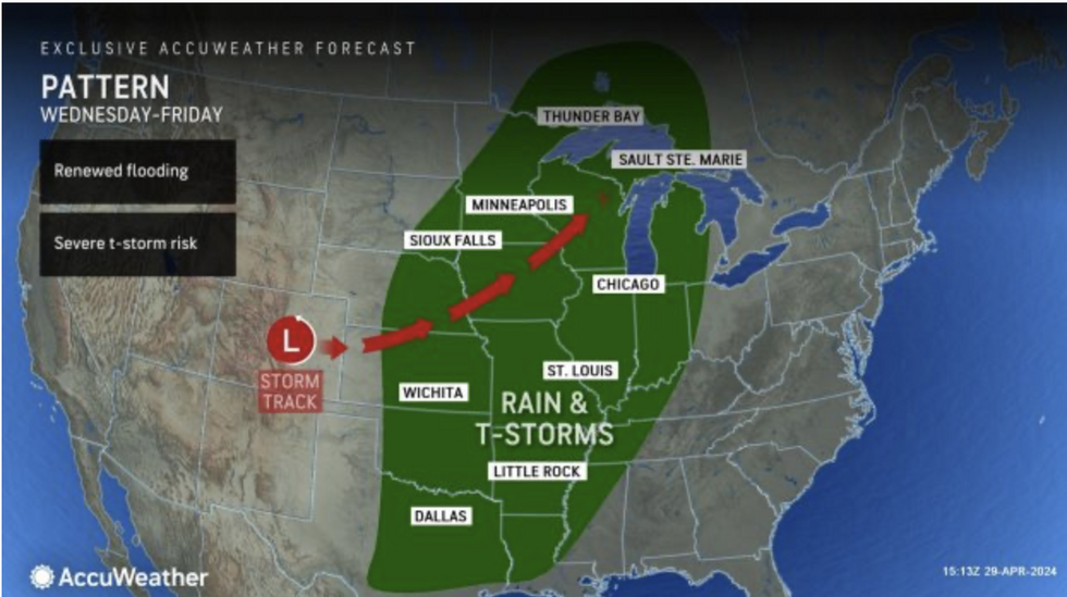
Accuweather meteorologist Bernie Rayno said: “The threat of severe thunderstorms on Wednesday stretches more than 900 miles from central Nebraska and southern Iowa to west Texas.
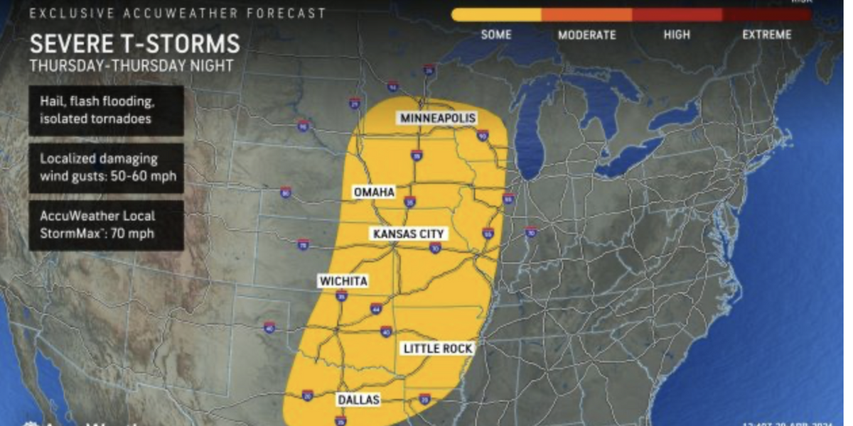
“The severe weather threats will extend east on Thursday, stretching from Texas to Minnesota, and across a major swath of the central United States to the Mississippi River.
“Hail and damaging wind gusts are the main severe weather threats but isolated tornadoes are also possible, and rounds of downpours and storms could lead to flash flooding in areas where the ground is already saturated after recent storms.”
The National Weather Service (NOAA) has issued ‘flood watch – prepare to take action’ warnings across southern states in the firing line for the deluge.
Separate flood advisories are in force across Kansas, Arkansas, Missouri, Oklahoma, Illinois, Nevada, Montana and Idaho.
Large hail, damaging winds, tornados and thunder are also in the forecast with ‘multiple rounds of heavy rain’ threatening ‘flash, urban, and river flooding.”
A NOAA spokesman said: “May kicks off with severe weather and excessive rainfall threats over the Central US.
LATEST DEVELOPMENTS:
“Severe storms and excessive rainfall threats shift into the Mississippi Valley on Thursday as low pressure moves into the regions.
“Thunderstorms, with some potentially severe, originating from the Southern High Plains will grow as they propagate into a very moist environment.”
Further north, across Montana, rainfall ahead of the weekend over high ground will turn to snow, the NOAA added.
The latest warnings follow a spate of storms which have unleashed havoc across the United States since mid-April.
Warm air from the south hitting cold air to the north, and supercharging the jet stream, is partly to blame.
A run of low-pressure systems have hitched a ride on the jet before being whipped across the country on a destructive storm path.
Weather Channel meteorologist Chris Dolce said: “Storm-weary parts of the Plains and Midwest will see more severe weather and possible flooding rainfall on the heels of several rounds of damaging storms that have affected those regions since late last week.
“This most recent bout of severe storms began Tuesday afternoon in the Midwest and Plains with just over a dozen reports of tornadoes tallied in parts of Oklahoma, Kansas and Iowa.
“A few storms could turn severe on Thursday and produce gusty winds or hail from the upper Mississippi Valley southward to Texas.
“Heavy rainfall from eastern Texas and northern and western Louisiana to the upper Mississippi Valley and western Great Lakes could trigger flash flooding.”
Jim Dale, meteorologist for British Weather Services, said: “Frontal systems will continue to bring very unsettled conditions to the US this week.”
At least five people have died in severe weather this week, according to The Weather Channel.
More than 120 tornadoes have been reported across the Plains and Midwest since the end of last week, it said.
Mr Dolce added: “That number is expected to rise since the National Weather Service needs to complete surveys, which will take days.”


Post comments (0)