A ‘tropical disturbance’ in the Atlantic may burgeon into another major storm just weeks after Hurricane Beryl unleashed devastation across the American coast.
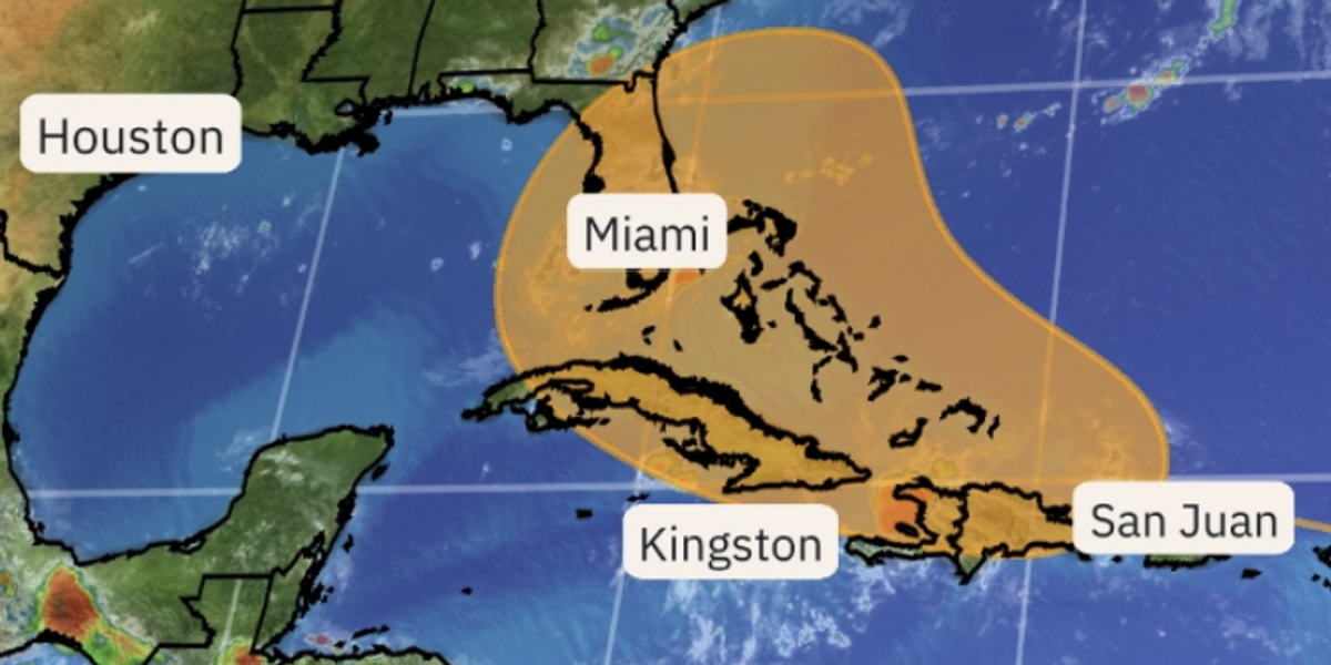
A ‘large tropical wave’ threatens to strengthen in ‘favourable conditions’ across waters near the Bahamas, according to concerned meteorologists.
Storm activity has been subdued over the past weeks by a huge Saharan dust cloud drifting over the Atlantic basin.
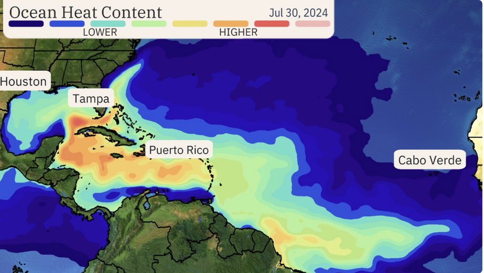
But clearer skies and warm ocean temperatures are providing the perfect ingredients for another storm to form later this week.
 US weather: Large ‘tropical disturbance’ threatens another major storm in just daysThe Weather Channel
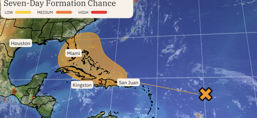
Weather Channel meteorologist Tiffany Savona said: “The National Hurricane Centre is giving the disturbance in the Atlantic a medium chance of developing into a tropical system by the middle to the end of the week.
“Ocean temperatures are much warmer than average in the 80Fs and 90Fs which will be very conducive to development.
“The tropics have been very quiet lately but don’t let your guard down now, as activity is expected to ramp up in August as we approach the peak of the season.”
‘Cone’ graphs showing a region of storm formation should not be taken as a path of the possible storm, she said.

Tropical set up in the Atlantic as the storm forms
The Weather Channel
If the disturbance grows, disruption could occur across the Caribbean or the southern flank of the United States.
It comes after Hurricane Beryl struck the region at the start of July, killing at least eight people after slamming Texas and Louisiana.
She was the first Category-5 hurricane to form this early in the season and left a path of destruction across the Caribbean.
Winds reached 75mph with near 90mph gusts recorded inland as the storm hit the southern states.
This year is expected to be particularly active for hurricane activity–in part because of higher ocean temperatures but also the effect of an El Nino warming of the east Pacific.
In addition, a pattern of rainfall across the Indian and Pacific Oceans – the Julian-Madden oscillation–will help drive this year’s storm season.
US LATEST:

Ocean heat content
The Weather Channel
A spokesman for The Weather Channel said: “The Atlantic has been accumulating Saharan dust since Hurricane Beryl’s demise roughly three weeks ago.
“This perk up of activity comes amidst the beginning of the most active time of the year in the tropics and a wave of more favourable atmospheric conditions known as the favourable phase of the Madden-Julian Oscillation.
“This wave travels around the globe once every 40 or so days and gives a boost to the tropics as it passes over.”
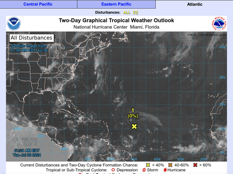
The US National Hurricane Centre said development of a stronger storm could happen later this week.

Two-Day Graphic Tropical Weather Outlook
National Weather Service
It forecasts a 60-per-cent chance of formation before the weekend with a lower chance over the next 48 hours.
A spokesman said: “A large tropical wave cantered several hundred miles east of the Leeward Islands is producing limited shower activity due to dry air aloft.
“Environmental conditions are forecast to become more conducive for development over the warmer waters of the southwestern Atlantic Ocean during the next day or two, and a tropical depression could form late this week while the system is in the vicinity of the Greater Antilles or the Bahamas.”
Jim Dale, meteorologist for British Weather Services and co-author of ‘Surviving Extreme Weather’, said: “At the moment this is something we are watching for the potential for development later in the week.”


 US weather: Large ‘tropical disturbance’ threatens another major storm in just daysThe Weather Channel




Post comments (0)